Saturday 10 October 2015

Rothenburg Germany

Plonlein (Little Square) is perhaps the most photographed scene in Rothenburg
To celebrate our anniversary this year we travelled back in time and travelled a small portion of "The Romantic Road": a scenic route through the southern portion of Germany doted with beautiful scenery and quaint towns. Along this route, and within the Franconia region of Bavaria, is the town of Rothenburg ob der Tauber. The name is interpreted as the "Red fortress above the Tauber". This is a well preserved medieval fortress town located above the Tauber River. And, yes, all of the buildings have red tile roofs …or at least this is the way we understand it.

The town founded in 1170 has a storybook look and feel and was a great place for us to celebrate. It is considered an idyllic example of a German Medieval community and has been the inspiration for, and featured in, many familiar stories and films. Among a long list it was the basis for the village in Walt Disney's Pinocchio, used for the filming of Chitty Chitty Bang Bang, was also used in the filming of Harry Potter and the Deathly Hallows. Some damage did occur as a result of bombing during World War II however a special arrangement was made to surrender the town to the American forces without defence so that it would not be destroyed. As a result, today it looks very much the way it did so long ago.

Rothenburg has hosted a traditional Christmas Market for over 300 years. It's easy to imagine how beautiful this town would be decked out with Christmas decorations and it's no wonder it's a top destination for tourists hoping to enjoy a quintessential Christmas experience. It's October, though, and instead of snow and twinkling lights, Mother Nature provided her own spectacular experience in the form of a clear, crisp day and beautiful fall colors.

Rathaus, town hall
The Rathaus, or town hall stands out in the centre square and just has to be  explored. The structure has two very different parts. The Gothic portion of this building, the white painted portion shown in the picture below, dates back to 1250 and has a tall white bell tower. The Renaissance portion shown above dates back to 1572. It has been the seat of government from the medieval times. The town hall tower has a viewing platform which is 220 steps climb from the front door, taking you 52 meters above the market square. The panoramic views of the town are well worth the 2 Euro toll and on a beautiful fall afternoon are nearly irresistible.

Marktplatz (Market Square) with the Ratstrinkstube (Chancillor's Tavern) on the right. 
The Ratstrinkstube (Councillor's Tavern) holds a very large clock with life sized animated figures. On the hour the two windows on either side of the clock face open revealing the figures. Crowds gather on the hour to see the show so we joined them.

Fleisch-und Tanzhaus (the Meat and Dance House): the large half-timbered structure served as a meat market by day and a dance hall by night.
This really neat old truck is parked in front of the Christmas Museum and one of the largest Christmas Shops we have ever seen. Here it is Christmas all year round. Of course we shopped here!


Markustrum (Marcus Tower)

One of the eye catching tower gates is Markustrum ( Marcus Tower) and includes the Roderbogen (Roder Arch). These gates form a part of an inner fortification well inside of the town wall system. The connecting town houses decked out in flower boxes together with the arch and clock tower make for a beautiful sight.

Below is the town hall bell tower. Scott is the one on the right with a camera in his hands. The views of the town from up here are really special. You can follow the town wall all the way around and note each of the towers and gates. There is no doubt here about the abundance of red roofs leading to the name of the town.


We enjoyed a really wonderful, although extremely filling, traditional German dinner here. Afterwards we decided a walk around town was in order. The lighted storefronts and softly lit buildings made for a beautiful stroll. We especially enjoyed all of the store windows.

Scott posing next to a really
big beer stein!

This bike is covered in crochet work, not painted!


We took a long walk along the top of the city walls and ended up at these gates. This is the way in to town from the south. It is the Spitaltor or Spital Gate and it is an impressive structure built in the form of a figure eight in the 16th century. There is an inscription here that reads "Pax intrantibus, salus exeuntibus" translated as "Peace to all who enter in, good health to this who leave again". Sounds good to me! The structure has several levels where cannon would have been placed and has a series of seven gates, twisting passages, and even a draw bridge. It would not have been easy to sneak into the city from here.


Friday 9 October 2015

Schweinfurt Germany


We were able to join part of our family in Germany as they enjoyed seeing the sights and, more importantly, remembering the role of the peace keeping force that served here following World War II. We met up with them in Schweinfurt, a picturesque river front town in the lower Franconia region of Bavaria. The name literally means "swine ford", as in "pigs". 

The history of this town is documented from the year 790 and it was the seat of great power and conflict through the ages. Schweinfurt became a proper city in the 13th century when a city wall and defensive towers were constructed. The city joined Martin Luther's Reformation in 1542 and the Protestant Union in1609. Schweinfurt was the site of conflict and occupation in the years following when it was both destroyed and reconstructed. Some of the city fortifications remain today.

We were treated like family here. The pubs and restaurants served us great "bier" and very nice traditional German food including schnitzel, pork shoulder, bratwurst, sauerkraut and, of course apple strudel, along with an abundance of warm and friendly conversation.

The Schweinfurter Rathaus Square

The Gothic Town Hall circa 1570
Food! And lots of it!

Family
Great memories!

Some memories of the not so distant past and keeping the peace…thank you for your service!

During World War II Schweinfurt was the home of ball bearing factories that supplied most of the needs for the Nazi war machine. Because of this the town became a strategic target and was bombed 22 times seeing a total of 2285 aircraft overhead.  Much of the city was destroyed. 

After the war the town become home to a US Army Garrison for the peace-keeping force. The base was operated until 2014 and was an important part of the community. We visited the "Museum Stammheim", a local museum that features a collection of hardware spanning both World Wars and the post-war area. The museum has provided equipment for the production of a number of movies including the 2013 Hollywood production of Monuments Men.

Schweinfurt is a fast growing city today of over 50,000 residents and is home to expanding industry including high tech ball bearing production.

F84 Thunderstreak West German fighter from 1950's 
A relic from 1915


No explanation is needed here…good luck for all!


There is some debate over the origins of the name Schweinfurt. The local residents seem to be fond of the explanation that little pigs crossed here at the ford. The German expression "Schewein haven" means "to be lucky" and the Schweinfurters consider themselves to be lucky people. Who are we to argue with that?


Thursday 1 October 2015

County Kerry: The Dingle Peninsula

The road to Tralee
County Kerry, Dingle Peninsula
We wanted to go back to Ireland to explore some of the cherished Irish countywide, so, we jumped in a car in Dublin and made our way westward across the country to County Kerry and the Dingle Peninsula. The Dingle Peninsula is the most western point in Ireland making this the closest point in Europe to America. It is 10 miles wide and 40 miles long stretching from Tralee to Slea Head. It is bounded by dramatic coastlines of rocky cliffs and sandy beaches and has picturesque mountains right down the middle. Contained within is Mount Brandon which at 3130 feet high is the second tallest mountain in Ireland.

We set up shop in the town of Dingle where we visited only five of the several dozen Irish Pubs where we enjoyed a Guinness or two, had some very fine meals, and were treated to traditional Irish music. We were told that there are 1300 full time residents in the town and that there are 500,000 sheep on the peninsula. We did see lots of sheep and yes there are many shades of green here.

The town of Dingle home to so many great pubs
"sláinte"


One of many sandy beaches on the Dingle Peninsula.

Riasc Ogham Stone

Ogham Stones, created as early as the 4th century, can be found throughout Dingle and county Kerry. These stones, written in primitive Irish, are mostly believed to be inscribed with names. There are several theories about the purpose of these monuments, but generally it's believed that they were markers of land ownership. The one above is a little different than most. It stands at the ancient monastic site of Riasc. It is decorated with an encircled Greek cross with pendant spiral designs. The letters "DNE"-D(omi)ne-O Lord are carved into it. This stone was decorated in Early Christian times.

Our explorations took us by car along narrow country roads, so similar to those we enjoy here in Cumbria. We were surprised to find fuchsia  growing wild along many of the roadsides. We learned that while this is not indigenous to Ireland it thrives here, and is welcomed for adding a bit of bright color to the landscape. 


Off the beaten path we visited Kilmalkedar Church. The ancient monastery of Kilmalkedar was founded here in the 7th century. This Romanesque church building remains dating back to the 12th century. There are a number on ancient artifacts here including an Ogham stone inscribed with a hole at the top indicating it may have been used as a contract sone


Dingle holds on strongly to its irish identity. This region is a part of Gaeltacht, which is a region where the irish culture and language are preserved. The schools here conduct their lessons in Gaelic and the children often begin life with English as a second language. This has also been the site for a couple of Hollywood movies including the 1970 film, Ryan's Daughter.

We learned a bit about the history of the Dingle Peninsula, including a bit about the Great Potato Famine of 1845 when the population of Ireland was cut in half.


In the 6th century from this quiet bay a monk, St Bernard, is said to have set sail in a leather boat on his way to America. That would have put him in America well ahead of Christopher Columbus. There is a mountain named after him.

The ruins of Min Aird Castle sit up on a bluff overlooking the sea and Storm Beach. The castle was attacked by Cromwell's Army in 1650. The castle was placed under siege which ended when explosive charges were set on each of the four corners causing structural damage that can still be easily seen today.


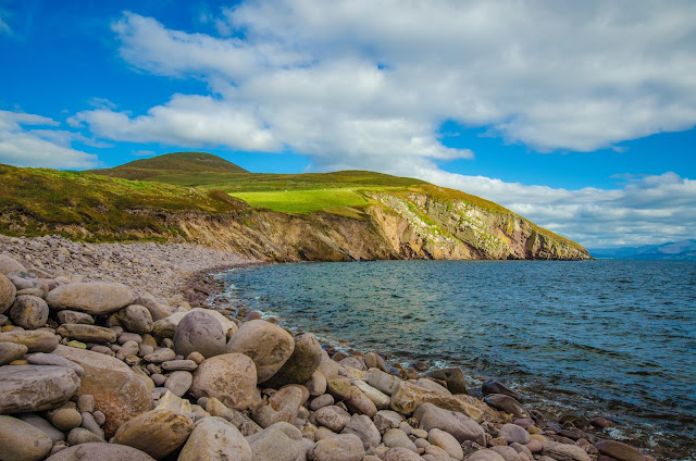
Storm Beach is made up of very large surf worn boulders and the cliffs beyond. 

These "Beehive Huts" are sprinkled all over the countryside. They are believed to date back to medieval times when they served a variety of needs for shelter from a place for livestock to the family home. Some stand alone like this one and many are build in connected groups. 

The locals kept a watchful eye on us... 
This is a view of Mount Brandon from the top of Conor pass. Really nice!

Out in the middle of a farmer's field stands a really great ancient church.  The Gallarus Oratory is a 1300 year old stone church. The stones are fitted dry with no mortar. The building remains in tact and is for the most part water tight. Very impressive craftsmanship. 


Very dramatic scenery is everywhere.
Ogham Stone


If you look closely at the Ogham Stone here you can see marks along the sides. These are actually  letters in Primitive Irish.


The sign says surfing lessons and indeed we did watch a group giving it a try.

"Éirinn go Brách"